MODIS Aerosol Optical Depth (AOD) data description
The Level-2 MODIS AOD file contains:
1) Geolocation Fields: Latitude, Longitude
2) Data Field: ~ 65 science data sets (SDS)
- Scan start time
- Solar geometry
- Aerosol optical depth both over land (3 bands) and ocean (7 bands)
- Deep blue aerosol optical depth over land
- Combined Dark target and deep blue aerosol optical depth
- Quality flags (i.e. land sea flag, quality assurance land, quality assurance ocean)
Two operational algorithms are used to retrieve AOD from MODIS over land: Dark-Target (DT) over vegetated land surfaces (Levy et al., 2013), in addition to operational ocean retrievals (Levy et al., 2013), and deep blue (DB) over bright surfaces (e.g. arid/desert regions) (Hsu et al., 2013). There is a third MODIS AOD product known as the MAIAC aerosol dataset available at 1 km x 1 km spatial resolution. More information about the MAIAC AOD data is available at https://modis-land.gsfc.nasa.gov/MAIAC.html.
For the purposes of the ACAM training school, we will only go over MODIS Dark Target and Deep Blue aerosol products, both are available at 10 km x 10 km spatial resolution, whereas the Dark Target product is also available at 3 km x 3 km spatial resolution. MODIS aerosol data products are currently in their 6th operational version known as Collection 6.1.
Aerosol Optical Depth from MODIS can only be retrieved in cloud-free observations, i.e. when there is no cloud cover present in the same pixel. For persistently cloudy regions, e.g. areas around Indonesia, aerosol retrievals by MODIS is significantly sparse because of the frequent cloud-cover. This does not mean there are no aerosols present in the atmosphere over a cloud field (or pixel), but only suggests that aerosol observations from space can be made in cloud-free conditions from passive remote sensing observations including MODIS.
- More scientific information about the MODIS aerosol data over land and ocean is available here.
- Additionally, details about the quality assurance for collection 061.
- More scientific and data usage information about MODIS Deep Blue and Dark Target aerosol products is available from the DB and DT links here and here.
Uncertainty in MODIS AOD product (this is very important when analysing and visualizing the data especially when writing a paper):
The expected error of AOD retrievals:
For Dark Target: ±(0.05 + 0.15τ) over land (Levy et al., 2013)
+(0.04 + 0.10τ), -(0.02 + 0.10τ)) over ocean (Levy et al., 2013)
For Deep Blue: ±(0.03 + 0.2τ) (Sayer et al., 2014) where τ represents AOD.
MODIS sensor specific information
MODIS (Moderate Resolution Imaging Spectroradiometer) is one of the key sensors onboard the Terra and Aqua satellites, launched in 1999 and 2002, respectively. MODIS provides nearly complete global coverage every 1-2 days with a swath of 2330 km from a polar-orbiting, sun-synchronous, platform at an altitude of 705 km (Remer et al., 2005). MODIS measures the top-of-atmosphere (TOA) reflectance and radiance in 36 spectral bands ranging from the visible (0.415 μm) to infrared (14.235 μm) with 19 reflective solar bands (≤ 3.9 µm) and 17 thermal emission bands. The spatial resolution (at nadir view) is 250 m for 2 bands (0.65 and 0.86 μm), 500 m for five bands (0.47, 0.55, 1.24, 1.63 and 2.11 μm) and 1000 m for the remaining channels. MODIS orbit pass is divided into each 5 minutes of granules, which individually cover ~2000 km x 2340 km of area. It generated 288 granules/day.
Data distribution sites (HDF format)
- L1B (calibrated, Geolocated) & Atmosphere (relevant for training school)
- Land
- Cryosphere (Snow/Ice) data sets
- Ocean
MODIS data are available in HDF format. Information about HDF format is available here.
Example of MODIS AOD over southern Asia: Climatology of monthly mean aerosol optical depth for April, May, and June from daily Level2 Aqua MODIS aerosol products (dark‐target and deep blue) for the period 2003–2009.
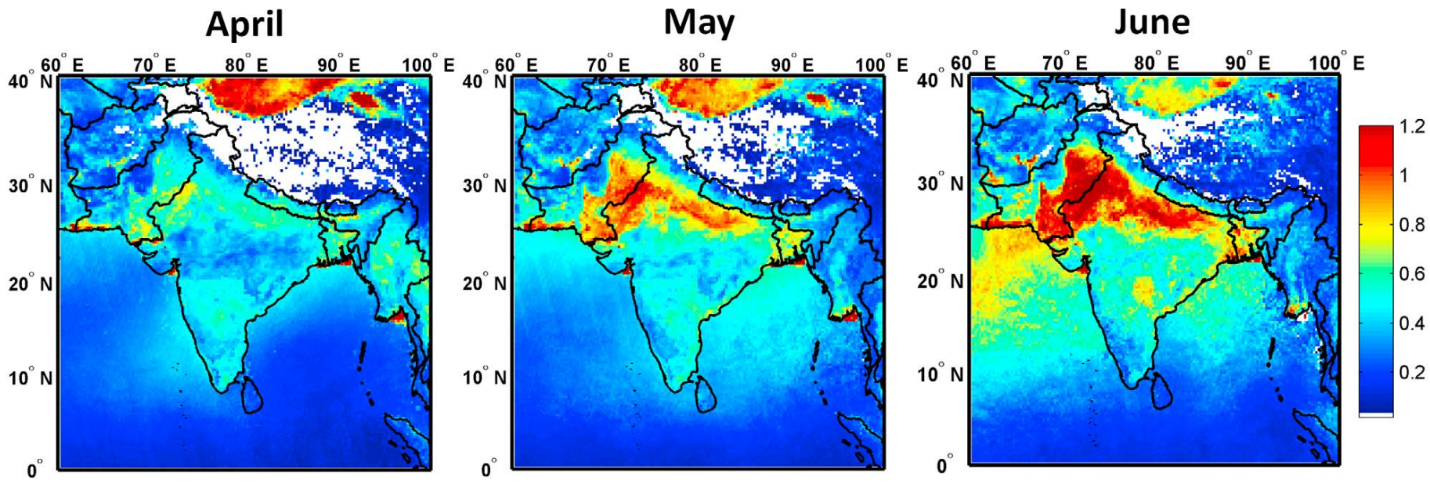
Gautam, R., Hsu, N. C., & Lau, K. M. (2010). Premonsoon aerosol characterization and radiative effects over the Indo‐Gangetic Plains: Implications for regional climate warming. Journal of Geophysical Research: Atmospheres, 115(D17). https://agupubs.onlinelibrary.wiley.com/doi/epdf/10.1029/2010JD013819
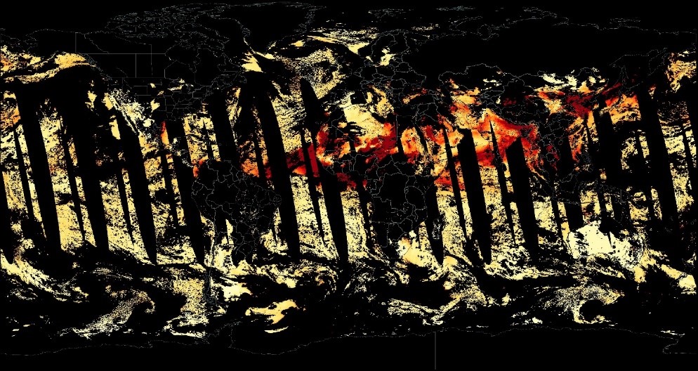
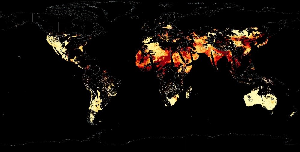
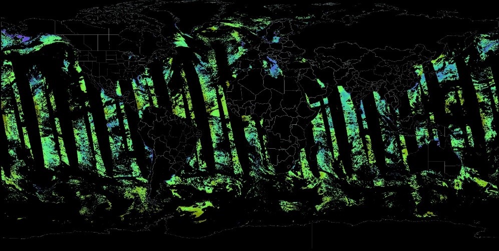
Examples of global MODIS AOD from WorldView site (warm colors denote high aerosol pollution)-
1) MODIS merged AOD Image (Deep blue + Dark Target) (28th March 2018) from NASA WorldView
2) MODIS Deep Blue AOD Image (28th March 2018)
3) MODIS dark target AOD_over_ocean Image (28th March 2018)
References:
- Hsu, N. C., Jeong, M. J., Bettenhausen, C., Sayer, A. M., Hansell, R., Seftor, C. S., et al. (2013). Enhanced Deep Blue aerosol retrieval algorithm: The second generation. Journal of Geophysical Research Atmospheres. https://doi.org/10.1002/jgrd.50712
- Levy, R. C., Mattoo, S., Munchak, L. A., Remer, L. A., Sayer, A. M., Patadia, F., & Hsu, N. C. (2013). The Collection 6 MODIS aerosol products over land and ocean. Atmospheric Measurement Techniques. https://doi.org/10.5194/amt-6-2989-2013
- Remer, L. A., Kaufman, Y. J., Tanré, D., Mattoo, S., Chu, D. A., Martins, J. V., et al. (2005). The MODIS Aerosol Algorithm, Products, and Validation. Journal of the Atmospheric Sciences, 62(4), 947–973. https://doi.org/10.1175/JAS3385.1
- Sayer, A. M., Munchak, L. A., Hsu, N. C., Levy, R. C., Bettenhausen, C., & Jeong, M. J. (2014). Modis collection 6 aerosol products: Comparison between aqua’s e-deep blue, dark target, and “merged” data sets, and usage recommendations. Journal of Geophysical Research. https://doi.org/10.1002/2014JD022453