Principles of measuring the oceans from space - SST
Within this book you will find summary information about SST measurements that are made by the Sentinel 3 satellite and make up part of the Copernicus Marine Data Stream from EUMETSAT.
1. Principles of SST
What is sea-surface temperature?
At first glance, this may seems like a fairly obvious question, but, in practice, extracting information about the ‘surface’ temperature of a three-dimensional fluid has a number of subtle implications; not least of which is, what do we actually mean by surface? In practice, the upper 10 m of the ocean has a complex and variable vertical thermal structure that is related to ocean turbulence and air-sea fluxes of heat, moisture and momentum.
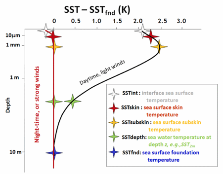
Figure 1. Definitions of sea-surface temperature parameters (credit; GHRSST).
Accurate measurement of SST from highly stable sensors is essential for climate monitoring. However, we also need clarity with respect to which temperature we are, in practice, actually measuring. To formalise how we discuss these measurements, the Group for High Resolution Sea-Surface Temperature (GHRSST) have defined a theoretical framework that we can use to describe and compare sea surface temperature as measured by satellite and in situ sources (Figure 1). The definitions for each variable can be found at the GHRSST website; https://www.ghrsst.org/ghrsst-data-services/products/.
As with ocean colour, SST is measured using radiometry, but rather than quantifying irradiances in the visible spectrum, we are interested in measuring the radiometric signal from the thermal infrared (TIR) and/or microwave component of the electromagnetic spectrum. The SST actually measured is innately related to the type of radiometer we use, as this determines the penetration of the signal - for a brief overview of SST radiometer types, see section 3: Sentinel 3: historical context and instrument overview. For example, an infrared radiometer, operating with a frequency of 3.7 to 12 µm would measure a good approximation of the SSTskin temperature of the ocean - e.g. the temperature of the top 10 µm. Conversely, a microwave radiometer measuring in the 6 to 11 GHz frequency range, would retrieve a temperature value that approximates the SSTsubskin temperature - e.g. the temperature of the top 1 mm. However, as you can see from the figure, the temperature variability in the top 10 m of the ocean depends on what time of day we make measurements (day or night), and on the the prevailing wind conditions (light or strong). In the daytime and during light winds, skin and subskin measurements can differ from the foundation temperature by as much as 2.5 K. To further complicate matters, while infrared sensors offer higher spatial resolution than their microwave counterparts, the former are unable to see through cloud, often limiting coverage.
How do we measure SST?
SST is passively measured (e.g. the satellite does not 'emit' a signal, it just receives a solar radiation reflection) and is not measured directly. To determine it we must begin by calibrating and correcting the raw antenna counts received by the onboard radiometer to arrive at an intermediate variable, the top of atmosphere (TOA) brightness temperature (BT). A brightness temperature (BT) is a measurement of the radiance of the radiation traveling upward from the top of the atmosphere to the satellite, expressed in units of the temperature of an equivalent black body. A brightness channel determination is made for each relevant channel in the radiometer.
As it scans, the radiometer passes over two internal reference sources - a cold and a warm blackbody - which enable the raw counts received by the antenna to be calibrated. In many cases (e.g. for the Sentinel-3 VISCAL routine), the calibration step required to produce a brightness temperature requires the satellite to repeatedly scan a ground target of known reflectance, to enable the more robust calculation of a BT.
Once we have derived BT we can derive our SST. There are a number of algorithms to do this, and in many cases multiple algorithms are used and their results subsequently combined. Irrespective of the algorithm approach used, the selection of the channels that are used in these calculations depends on radiometer type we are concerned with (TIR/MW) and the prevailing day/night conditions. The relevant BTs are then used to determine our SST at the specified time and gridded position, via a regression process.
It is important to bear in mind that, while the satellite is attempting to measure the sea-surface, the signal we record at TOA also contains the imprint of the thermal signature of the atmosphere, which me must correct for. Newer radiometry satellites approach this problem by making SST estimates twice for each point on the Earth’s surface during a single overpass - a process known as dual view. A dual view satellite operates two scanning mirrors, which allow the radiometer to scan a swath at across its track and directly under the satellite (nadir) and again over a second swath behind the satellite (oblique) (Figure 2).

Figure 2. Nadir and oblique swaths made by a dual-view radiometer.
As the distance travelled through the atmosphere is different for the two views, the effects can be characterised and well corrected for.
References and resources:
https://www.ghrsst.org/ghrsst-data-services/products/
http://research.metoffice.gov.uk/research/nwp/satellite/imagery/sst.html
http://www.remss.com/measurements/brightness-temperature